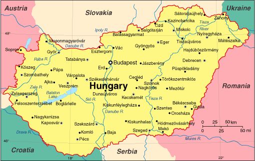
 Official name: Hungary
Area: 93 030 km2
Population: 9 900 000
Neighbouring countries: Austria, Slovakia, Ukraine, Romania, Serbia, Croatia, Slovenia
Official language: Hungarian
State form: Parliamentary republic
Capital and largest city:Budapest (population: 1 700 000)
Other large cities: Debrecen, Miskolc, Szeged, Pécs, Győr
Currency: Forint (HUF)
Time zone: CET (GMT +1)
Major rivers: River Danube (417 km), River Tisza (597 km)
Largest lakes: Lake Balaton, Lake Velence
Highest point above sea level: Kékes (1014 m) in the Mátra Hills
State administration:
- The President of the country, elected by the National Assembly every 5 years, has a largely ceremonial role, he represents the nation’s unity and safeguards the democratic functioning of state administration.
- The Prime Minister selects cabinet ministers and has the exclusive right to dismiss them. Each cabinet nominee must be formally approved by the president.
- The unicameral, 386-member National Assembly is the highest organ of state authority and it initiates and approves legislation sponsored by the Prime Minister. National parliamentary elections are held every 4 years. A party must win at least 5% of the national vote to form a parliamentary group.
Hungary is a member of OECD, NATO, EU and a Schengen state.
Administratively, Hungary is divided into 19 counties with the capital city of Budapest being independent of any county government.
Hungary is one of the 15 most popular tourist destinations in the world with a capital regarded as one of the most beautiful cities. Despite its relatively small size, the country is home to numerous World Heritage Sites, UNESCO Biosphere Reserves, the second largest thermal lake in the world (Lake Hévíz), the largest lake in Central Europe (Lake Balaton), and the largest natural grassland in Europe (Hortobágy).
Source: Tempus Public Foundation


